Media Contact: Jordan Rutter, Director of Public Relations| jerutter@abcbirds.org | @JERutter
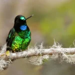
The Glittering Starfrontlet, a species included in the new study, is one that ABC has worked to conserve with local partner Fundación ProAves at Colibrí del Sol Reserve in Colombia. Photo by Dubi Shapiro
(Washington, D.C., December 1, 2021) A new study published in the open-access scientific journal PLOS ONE by conservationists at American Bird Conservancy (ABC), BirdLife International, Cornell Lab of Ornithology, Duke University, International Union for Conservation of Nature (IUCN), and Saving Nature uses an innovative new method to rapidly produce range maps for birds using a combination of crowd-sourced bird records combined with satellite data on forest cover and elevation. This work has revealed that many species have larger ranges than previously known — but that the range actually habitable may be quite small.
The team produced new range maps for the more-than-1,000 forest-dependent bird species across Central and South America at greatest risk of extinction, using 350,000 observations from eBird, an online platform used to record bird sightings. The new maps will be important tools for use in conservation decision-making and prioritization.
“These maps will help us identify which bird species are under-protected and where new conservation areas are needed to ensure all Endangered and Critically Endangered bird species are conserved,” says Daniel Lebbin, co-author and ABC Vice President of Threatened Species. ABC works with local partners in Latin America and the Caribbean to close the gaps in coverage to best conserve habitats and protect existing reserves for the most threatened birds in the Americas.
The maps provide new levels of detail to aid conservation efforts. Most existing maps show the distribution limits of each species: a boundary broadly encompassing known and projected presence. The newly created maps show “Areas of Habitat,” ranges refined by suitable elevation and land cover for individual species, as well as known areas where the species are absent. The Area of Habitat concept provides a more precise measurement of how much suitable habitat is available to a species.
The authors found that including crowd-sourced bird records from the global birding community extends the mapped distributional limits for quite a few species. For instance, the White-chested Swift and Chestnut-bellied Guan are both ranked by IUCN as Vulnerable but have larger Areas of Habitat than prior ranges estimated. Overall, the new Areas of Habitat are on average 12 percent larger. “People are finding these species outside of where we previously knew they occurred, and that information is vital for conservation planning purposes,” says lead author Ryan Huang at Duke University.
Larger ranges are good news for many species, but the new maps revealed that some species are more restricted (and perhaps more threatened) than previously thought. For example, the Hoary-throated Spinetail in Brazil and Guyana has an Area of Habitat of only 6 percent of the previously published range.
“Conservation practice needs the very best maps we can produce to be effective. We believe this innovative approach produces them and, above all, allows us to update them as species ranges shift because of habitat loss or climate disruption,” says co-author Stuart Pimm, Doris Duke Professor of Conservation at Duke University.
Co-author and Chief Scientist at BirdLife International Stuart Butchart points out that: “Improving our understanding of species’ distributions will enable us to make more accurate assessments of their extinction risk using the categories and criteria of the IUCN Red List, which in turn helps set priorities for action.”
The team expects that the new methods soon will be applied to more species and taxa, and that they will incorporate more data sources in the future.
The study can be found online at DOI: 10.1371/journal.pone.0259299. The maps can be explored online here.
Official Citation: “Batch-produced, GIS-informed Range Maps for Birds Based on Provenanced, Crowd-sourced Data Inform Conservation Assessments,” R.M. Huang, W. Medina, T.M. Brooks, S.H.M. Butchart, J.W. Fitzpatrick, C. Hermes, C.N. Jenkins, A. Johnston, D.J. Lebbin, B.V. Li, N. Ocampo-Peñuela, M. Parr, H. Wheatley, D.A. Wiedenfeld, C. Wood and S.L. Pimm; Nov. 24, 2021, PLOS ONE. DOI: 10.1371/journal.pone.0259299 Online – https://journals.plos.org/plosone/article?id=10.1371/journal.pone.0259299
ABC would like to acknowledge the estate of Mary Janvrin for supporting this research.
###
American Bird Conservancy is a nonprofit organization dedicated to conserving wild birds and their habitats throughout the Americas. With an emphasis on achieving results and working in partnership, we take on the greatest problems facing birds today, innovating and building on rapid advancements in science to halt extinctions, protect habitats, eliminate threats, and build capacity for bird conservation. Find us on abcbirds.org, Facebook, Instagram, and Twitter (@ABCbirds).