One of the North Atlantic's Most Endangered Seabirds Now Being Tracked by Satellite
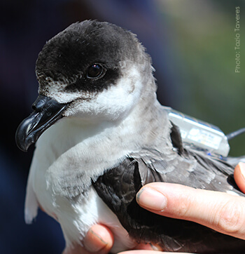 |
| A Black-capped Petrel equipped with a solar-powered satellite transmitter. |
(Washington, D.C., April 24, 2013) A new study has begun that for the first time will track via satellite one of the North Atlantic's most threatened seabirds—the Black-capped Petrel—to help better understand the movements and threats faced at sea by this globally endangered species. The tracking project is being led by the U.S. Geological Survey (USGS) South Carolina Cooperative Fish and Wildlife Research Unit at Clemson University, Grupo Jaragua in the Dominican Republic, and American Bird Conservancy.
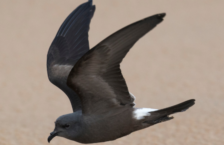
Black-capped Petrels are medium-sized (approximately 16 inches long with a 38-inch wingspan), truly oceanic seabirds. They come to land only to breed. There are only a handful of known breeding colonies, all in remote areas of Haiti and the Dominican Republic, and an estimated 600 to 2,000 breeding pairs. The species' nonbreeding range is currently known to include the U.S. coast, but it is possible that knowledge obtained via satellite tracking may expand that range.
Interest in the Black-capped Petrel is high not only because of its threatened status and the lack of detailed knowledge of its distribution and threats facing the birds, but also for cultural reasons. The species has developed a local, common name, “diablotín” or little devil, because of its nocturnal habits, which include its unusual, eerie calls and its tendency to produce a haunting, flute-like sound during nocturnal flights, apparently created by wind passing over its wings.
Satellite transmitters were placed on three birds on April 8 and 9 that will track daily locations and foraging trips for the next several months. The tags weigh approximately 10 grams, are solar-powered, and run for eight hours at a time before turning off for the next 24 hours to conserve power and to recharge. Locations are accurate to approximately 100–1,000 meters depending on the satellite coverage. Among the wide variety of tracking technologies, satellite transmitters yield some of the highest-resolution location data which, in spite of the very small numbers of individuals tracked, may provide extremely valuable information that may direct the design of future tracking efforts.
“This is a pioneering effort for this species that will yield unique information about the petrels' travel routes and foraging locations while breeding, the rate at which the birds provision their chicks over the course of the breeding season, and, we hope, their dispersal following breeding,” said Patrick Jodice of the USGS South Carolina Cooperative Fish and Wildlife Research Unit at Clemson University.
 |
An adult Black-capped Petrel equipped with a satellite transmitter is placed back in its burrow by René Jeune of Grupo Jaragua. |
The three birds are members of established pairs that are raising chicks this season in burrows high in the mountains of the Sierra de Bahoruco along the border between the Dominican Republic and Haiti. Once the transmitters were affixed, the birds were returned to their burrows. By April 12, all three birds had left their burrows and headed out to sea to forage. Petrels normally attend chicks for brief periods of time in between lengthy foraging trips at sea. They flew to waters over the undersea Beata Ridge approximately 60 miles south of the coast of Hispaniola. Then one bird headed due south to an area off the coast of Colombia's Guajira Peninsula; another southwest to waters off Panama and western Colombia; and the third bird flew around Hispaniola between Jamaica and Haiti, northeast over the Bahamas, and out into the Gulf Stream. Follow the birds' journeys.
“Already we are seeing unique, real-time data that are adding to our understanding of the ecology of this species. We are documenting 24-hour flights of 400-500 miles by these birds, and they are foraging in regions of the southern Caribbean Sea that were somewhat unexpected,” said Jodice.
Black-capped Petrel nests have been found only in several remote and imperiled areas of Haiti and the Dominican Republic. Those areas are facing ongoing rapid habitat loss, despite two of them being within designated protected areas in La Visite National Park in Haiti and Sierra de Bahoruco National Park in the Dominican Republic.
Much of the habitat loss stems from the desperate situation faced by communities on the Haitian side of the border, which depend on land for farming and fuel wood for cooking. As a result, the remaining nesting habitat for this species is rapidly becoming deforested and degraded. This affects the security of nesting colonies in Haiti, but also in the Dominican Republic, since Haitians are often hired by Dominicans to farm and make charcoal for them in the Sierra de Bahoruco, despite its protected area status. In addition, the species is believed to be threatened by losses from collisions with power lines and communication towers, the periodic outbreak of wildfires and fires associated with forest clearing for farmland, and non-native predators such as rats and cats.
The petrels may also face threats at sea, but learning what these are is a significant challenge. Petrels are pelagic seabirds that range over large areas of open ocean to forage. They may come into contact with oil spills, fisheries, and at-sea energy infrastructure such as wind turbines and oil drilling platforms. Similar to the risk posed by communication towers, lights on oil rigs or fishing vessels may attract petrels at night and lead to collisions.
“Beginning to build a map of the birds' foraging range during the breeding season is a first step in learning about where the birds may be exposed to these potential threats. In addition, identifying where the petrels spend their time at sea helps us see the patterns—currents and oceanographic conditions—that define the birds' foraging habitat,” said Rob Ronconi, a seabird biologist who led in the deployment of the tags.
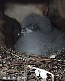 |
| Black-capped Petrel chick inside its nest in the Sierra de Bahoruco. |
He added that the findings will also enhance our understanding of the distribution and quality of this habitat and identify regions where at-sea conservation areas can provide protection for this species and other marine wildlife. In this way, scientists and conservationists can better discern the Black-capped Petrel's ecology at sea and determine how best to improve the species' conservation status.
“Because the species is so cryptic and only comes to land at night and nests in remote locations, locating nesting areas and individual nest sites is extremely difficult,” said Ernst Rupp of Grupo Jaragua, a leading conservation NGO in the Dominican Republic. “Since 2011, through a combination of technologies including radar, night vision, and thermal imaging, we and our partners at Environmental Protection in the Caribbean, Société Audubon Haiti, and Cornell University have located and monitored some of the only known nests of this species. That very difficult and arduous work to locate the nest sites has made tagging these petrels possible.”
“The island of Hispaniola harbors the last known breeding population of this species," said Holly Freifeld, ABC's Seabird Program Director, “so it is crucial that we not only protect these known nest sites, but also locate additional nesting areas that can be protected. Although Black-capped Petrels are well known to occur in waters off the east coast of the U.S., very little information exists about where they are foraging, and about their movements at sea during the breeding and nonbreeding seasons.”
The satellite tagging project is supported by American Bird Conservancy, Mohamed bin Zayed Fund for Species Conservation, Cary and David Paynter through the H. Smith Richardson, Jr. Charitable Lead Annuity Trust, Jeff Rusinow, South Carolina Cooperative Fish and Wildlife Research Unit, The Nature Conservancy, U.S. Fish and Wildlife Service, and Stuart and Lynn White.
Research and conservation work to benefit the Black-capped Petrel is being carried out by a wide variety of organizations including American Bird Conservancy, BirdsCaribbean, BirdLife International, Conservation Metrics Inc., Cornell University, Environmental Protection in the Caribbean, Grupo Jaragua, Instituto Tecnológico de Santo Domingo, Société Audubon Haiti, USGS South Carolina Cooperative Fish and Wildlife Research Unit at Clemson University, and the U.S. Fish and Wildlife Service. These organizations and many dedicated individuals collaborate through the International Black-capped Petrel Working Group.

